Geospatial information is valuable, but only if you know what you’re looking at and why it matters.
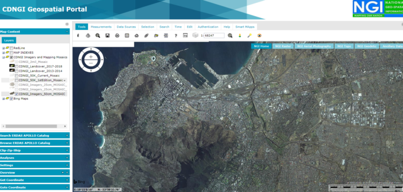
Officials at the Chief Directorate: National Geo-spatial Information (NGI) — the official mapping agency of South Africa — were aware of this and needed a solution to turn their data into actionable information, so they commissioned the dynamic, interactive Geoportal to meet their needs.
Hexagon partner Geospace International worked with NGI to build the Geoportal, which is powered by a variety of Hexagon products: GeoMedia Webmap, Geospatial Portal, ERDAS APOLLO, GeoCompressor, and Smart M.Apps. They work seamlessly together, making it easy to build custom solutions like the Geoportal.
Geospace created the customized application according to NGI requirements. Geospace and NGI then collaborated to formulate and configure the presentation of NGI enterprise data within the Geoportal.
Sharing Authoritative Information
The portal facilitates the capture, management, maintenance, integration, distribution, and use of spatial information. A prototype has been made available to the public so that NGI can easily distribute enterprise geospatial information.
Officials say the Geoportal has been especially useful in assisting NGI with implementing and enforcing lockdowns and sharing authoritative data during the COVID-19 pandemic. But the portal is also intended to enable social and economic development by providing easily accessible data to an inclusive user community.
Users can search for and discover imagery dating back to the 1920s, and the data is presented on a clear, easy-to-read map — the ideal format for geospatial data publication.
Before the development of the Geoportal, all enterprise data had to be structured and managed into functional data sets supported by documented procedures and standards. Now, the Geoportal organizes massive amounts of data with a functional data management strategy, centralizing previously siloed data sets in a single repository.
Data Sets and Standards
The Geoportal gives users access to NGI enterprise data, including national topographical vector data (cultural, hydrographic, hypsographic, land cover, land use, physiographic, and transportation data), current and historical aerial photography, national control survey network frame information, and current and historical maps.
This initiative enables compliance with the South African Spatial Data Infrastructure (SASDI), which was established to facilitate the capture, management, maintenance, integration, distribution and use of spatial information in accordance with national and international standards.
NGI is still analyzing client usage and interaction with the Geoportal as well as whether users are located in South Africa or abroad. The strength and value of the Geoportal is that it allows NGI data to be accessed from anywhere and by anyone, truly democratizing the data.
The Geoportal has transformed unorganized data into a smart, effective tool to aid officials in land development and reform. It also showcases the power of visualized location intelligence and the endless possibilities presented by customized solutions that make data work for you.


