Wildfires take a massive toll on their surroundings. The U.S. Natural Fire Protection Association reported that in 2017 alone, 1.3 million fires occurred, causing the loss of 3,400 lives and $23 billion in damage. And the U.S. is just one country affected by wildfires; with the increased effects of climate change, the risk of severe fires has increased worldwide.
The growing risk of wildfires raises an important question: how can fires be extinguished quickly so they cause as little damage as possible?
Fortunately, the latest advances in information technology, specifically the Luciad Portfolio, allow firefighting resources to be used more efficiently. They help firefighting units stay safe and move from one point to another using the shortest route possible by making calculations based on elevation data and details about the fire.
With elevation data, the path accounts for hills in the area. Fire data includes not only the current status of the fire but also predictions on its propagation based on several factors, such as weather and environmental factors. Integrating this information into the calculations ensures that the recommended path doesn’t require firefighters to pass directly through the blaze.
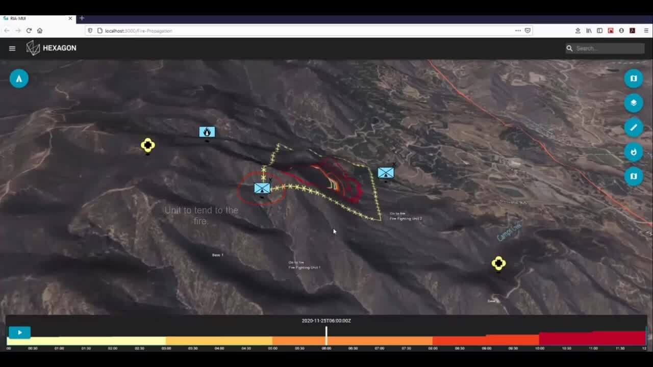
In LuciadRIA, firefighters have a tool that provides route guidance for units to safely navigate around fires, taking into account the propagation of the fire over time. The map is able to connect to an external service powered by the firefighting expert company Vexiza that predicts the behavior of fires.
With geospatial data collected in the field and other information, the service provides the propagation prediction as polygons associated with dates and times. This information is displayed on the map, color-coded so that the times of prediction rings correspond to the times selected on the controller at the bottom of the screen.
Users can select the point where a firefighting unit is initially positioned and the point that they would like to reach. LuciadFusion will then calculate a route that avoids the fire footprint predicted for that time. Once a route has been calculated, using the time controller recalculates the route based on any changes in fire prediction.
Safe routes calculated by Luciad technology allow firefighting units to plan, navigate, and report on blazes as they battle them. With data collection, analysis, and visualization, firefighters can work smarter, ultimately leading to better results from their efforts — less damage to the Earth, less money spent on combatting fires, and, most importantly, fewer lives lost.
Learn more about how Hexagon technology empowers emergency response efforts, and watch the video to see Luciad’s fire propagation capabilities in action.