On October 6, we released M.App Enterprise 2023, a significant update to our platform for creating geospatial and location intelligence applications.
The latest release enables users to create applications faster and delivers a seamless layout across desktop, browser and mobile components. Besides a completely updated design for an enhanced user experience, M.App Enterprise now offers the option to make applications available to the public.
M.App Enterprise has been a driving force in helping cities around the world improve resilience and sustainability. Its apps help users manage land and property; monitor and minimize emissions; analyze and predict traffic flow; determine optimum solar panel placements and more.
Tree data
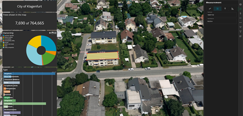
With the new public app functionality, advanced geospatial capabilities are now put into the hands of the public. Here’s an example of a public application from the city of Klagenfurt, Austria. It displays a digital twin of the city with the combination of a 3D mesh layer, true orthophotos and a digital elevation model.
On top of that, it features almost 8,000 trees that have previously been identified as positioned close to infrastructure. By clicking on the bar chart on the left, users can filter on the type of trees to find their locations on the map. The pie chart automatically updates and shows whether each tree is publicly or privately owned. This information might come in handy when you’re looking to harvest hazelnuts!
Daylight planning
The dashboard is not only useful for dendrophiles — it contains a lot more functionality. Event organizers can look up a specific place, and by using the measurement icon on the right bar, they can precisely measure the location where they’re planning to organize an event.
In the effect settings, they can switch on the Sun Light option and enter the date and time of the event, so they can see which areas will be shaded. The same functionalities can also be used by anyone who’s interested in installing solar panels anywhere in the city.
New toolset
More advanced users can try out some of the newly added features in this public application. With the tighter LuciadRIA integration, M.App Enterprise 2023 now includes a new toolset. The cross view enables you to precisely measure distances between your 3D data objects. The swipe view lets you compare two different data layers, horizontally or vertically. The line of sight gives you information about what is visible from a specific point in the map. Don’t hesitate to try it out yourself! It is perfectly safe to do this at home.
Have a look at our product page if you’re interested to learn more about M.App Enterprise.


