


In August 2019, Hexagon’s Geospatial division participated in the 62nd ISI World Statistics Congress in Kuala Lumpur, Malaysia. You might be wondering why a geospatial and location intelligence software company is attending an event where statisticians make up the majority of the audience. Isn’t that like a classical musician attending a hard rock festival? Believe it or not, there are more connections than you might think. During the congress, it became clear that national statistics offices have a real need for the tools our geospatial software can provide.
There are three areas identified during the sessions where geospatial technology can assist with industry challenges:
1. Remote Sensing for More Informed Decision-Making
Remote sensing is the acquisition of information about an object or phenomenon without making physical contact with the object. With the increased availability of satellite imagery at a lower cost than ever before, statistical agencies around the world can benefit from using satellite imagery data to improve official statistics on a wide range of topics spanning agriculture, the environment, business activity and transport. Satellite imagery has significant potential to provide more timely statistical outputs, to reduce the frequency of surveys, to reduce respondent burden and other costs and to provide data at a more disaggregated level for informed decision making.
2. Smart M.Apps to Monitor the Sustainable Development Goals
The Sustainable Development Goals are a call for action by all countries – low-income, middle-income and high-income – to promote prosperity while protecting the planet and its resources. They recognize that ending poverty must go hand-in-hand with strategies that build economic growth and address a range of social needs including education, health, social protection, and job opportunities, while tackling climate change and environmental protection.
Over the next 10 years, with these 17 new goals that universally apply to all, countries will mobilize efforts to end all forms of poverty, fight inequalities and tackle climate change, while ensuring that no one is left behind.
Countries have the primary responsibility for follow-up and review, at the national, regional and global levels, with regard to the progress made in implementing the Goals and targets by 2030.
Hexagon Smart M.Apps can help countries monitor their progress.
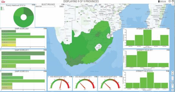
Below is an example of a Smart M.App showing poverty indicators progress over time in different geographical levels in South Africa.
3. HxGN Smart Census as a Cost-Efficient National Solution
The United Nations requires Member States to conduct at least one population and housing census every ten years. The information generated by a population and housing census – numbers of people, their distribution, their living conditions and other key data – is essential for policymakers so that they know where to invest. A census is the most important and costly statistical data collection exercise conducted by a national statistics office. HxGN Smart Census significantly decreases the cost and drastically increases the data quality of the census with its end-to-end solution that fully digitizes the entire census process.
Bridging the Technological Gap
For policy makers to make informed decisions, geospatial software should evolve from being an outlier to mainstream. From satellite imagery exploitation to census gathering to dynamic data analysis, there are needs within the statistical community that can greatly be impacted with the right technologies.
Take a closer look at how Hexagon’s technologies support Smart Nations.
