


Urban digital twins and advanced simulations can have a profound impact on addressing environmental challenges such as urban heat islands and optimizing urban airflow. Today, we invite municipalities to take the next step in transforming their urban landscapes by using these cutting-edge technologies through a data-as-a-service (DaaS) offering.
What is DaaS?
DaaS is a cloud-based service model that provides users with on-demand access to data, analytics and insights without the need for extensive in-house infrastructure or expertise. By leveraging DaaS, municipalities can access powerful simulation tools and data analyses to make informed decisions about urban planning and environmental management.
How can municipalities benefit?
Municipalities interested in identifying and addressing urban heat islands and wind tunnels can now access these insights through Hexagon’s DaaS service. It provides detailed simulations that reveal critical areas in need of intervention.
Here’s how it works:
- Input submission: Municipalities provide the necessary input (aerial picture, digital elevation model, digital surface model) for an area of at least 10 km² within their jurisdictions
- Free quality check: Hexagon conducts a complimentary quality check of the submitted data to ensure accuracy and reliability
- Simulation execution: Upon approval, Hexagon runs the simulation and generates comprehensive output files that clearly identify heat distribution and wind speeds at several heights as separate outputs
- Strategic collaboration: In the next stage, Hexagon collaborates with urban planners to simulate potential changes, such as removing a building or adding green spaces – this collaborative approach allows municipalities to visualize the impact of proposed changes before implementation, ensuring investments are made wisely and public funds are used effectively
By leveraging Hexagon’s DaaS offering, municipalities can gain valuable insights into their urban environments. This empowers them to make data-driven decisions that enhance livability and sustainability.
This proactive and iterative approach allows users to run various simulation scenarios. They can refine strategies and, ultimately, select the one that has the most favorable effect. Not only does this improve urban resilience, but it also fosters community trust by demonstrating a commitment to informed and responsible urban planning.
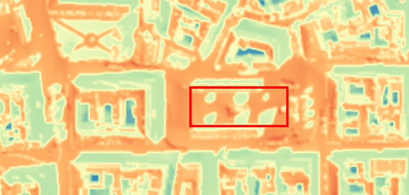
Example: The six dots in the red square represent the simulated surface temperature impact of trees of different sizes and foliage. This is before anything is actually planted.
Learn more
We invite municipalities to explore the possibilities of DaaS and urban digital twins. Join us in creating a future where technology and nature work hand in hand to build thriving, resilient communities.
Contact us today to learn more about how our DaaS service can benefit your municipality.

Christophe Plevoets is a product marketing manager specializing in geospatial solutions at Hexagon. He has been a pivotal team member since 2018. He has a rich background as a customer consultant, presales specialist and business development engineer, and he has honed his expertise in geospatial technologies and strategies. His diverse roles have equipped him with a comprehensive understanding of customer needs and market dynamics. This enables him to drive innovative marketing initiatives that enhance Hexagon’s geospatial offerings. Passionate about leveraging cutting-edge geospatial technology, Christophe is dedicated to empowering businesses to make informed, data-driven decisions.
