


Retired researcher E.A. (Ted) Dubowski is on a mission. Based in Mansfield, England, Ted has devoted considerable time to a Northeast Africa remote sensing research project titled, “Tectonic Geomorphology: Geodynamics and the Emergence of a Tethyan Continental Marginal Sea.”
Ted is looking for evidence, in the landforms and landscape, of the ancient sea from millions of years ago that no longer exists in its original form. He believes the sea is the main source of the sands of today’s Sahara Desert which were redistributed by palaeolakes and palaeodrainage systems. To do this extensive research, Ted is relying on ERDAS IMAGINE, Hexagon’s world-leading geospatial data authoring system, and ATCOR, an ERDAS IMAGINE add-on from Hexagon partner Geosystems.
“In all, this is a 10-year retirement project, and I will be making my findings available to all on a website I have developed,” he said. “The extensive Landsat imagery will be processed with ERDAS IMAGINE, which I will be using as a preferred software due to the techniques of ICS and decorrelation. The images will be draped over an SRTM-30 base map processed using a technique developed, Hillshade Normalisation, to interpret in detail the landform information.”
Ted is using ATCOR for atmospheric corrections.
Below is a synopsis Ted’s work so far.
The geomorphology and the structural geology (together the tectonic geomorphology) of the Sahara, North Africa in general, is the story of the demise of the southern continental margin of the Tethys Ocean. Excluding the igneous intrusions for the moment, the sedimentary sequences are of marine origin grading to estuarine/lacustrine and fluviatile material around shorelines that migrated with the rise and fall of the Tethyan Ocean sea level throughout its history, brought about by geodynamic earth movements. We know about the continental sea just by the nature of fossils in Wadi Al-Hitan to the west of the Faiyoum, southwest of Cairo, Egypt: the Valley of Whales.
The geodynamic movements were centred around the plate margins that expanded the Atlantic, Antarctic, Indian and Arctic Oceans whilst jostling and colliding the piggy-backed continents with each other; in this case, Africa colliding with Europe and Arabia colliding with Africa – itself being jostled on 3 sides by mid-ocean ridges and to the north colliding with and subducting under Europe.
The Tethys Ocean has a very long geological history being a large ocean to the east of the supercontinent of Pangaea, now only remnant basins we call the Mediterranean Sea, Black Sea and Caspian Sea. So, in essence, a long period of sedimentation from a very large continent into a very large oceanic basin over deep geological time, that changed in form, size, shape and with development of reef systems around the continental margins. Pangaea changed in time and space, the continents jostled about and were affected by various erosional and depositional centres as climate changed and sea level rose and fell.
I suggest that Tethys was closing much like a pair of tweezers – of global dimensions – with the closed end around Iberia and the northern European-Siberian landmasses being forced southerly due to opening of the North Atlantic and the Arctic and Africa and Gondwana landmasses moving northerly due to Antarctic opening followed by the opening of the Indian Ocean. The Atlantic and Indian Ridges could possibly have acted as some form of loose vice constraining overall movement of Africa until the Gondwana microcontinents started to meet and collide with the Eurasian and African landmasses. Subduction/obduction processes, and far field tectonic effects from India colliding with Eurasia, affected the collision of Europe-Africa-Arabia, as seen in the displacement and accommodation structures across the Himalayas and into Turkey, Greece and Spain, which ultimately closed the Tethys to the east. These movements ultimately started and developed another set of tectonic boundaries, the Red Sea and the East African Rift (EAR).
So, the story of Saharan sand needs to start with a continental margin sea and oceanic sediments. The northern margin of the (then) African continent was most likely a passive, continental margin into which flowed one/some large-scale rivers.
This is a personal research project in remote sensing that started as the palaeodrainage, geomorphology and structural development of arid landforms of Egypt. Initial focus was on the Western Limestone Plateau of Egypt. I enlarged the area of investigation as there is intense structural control of the wider region around this plateau particularly with respect to the wider drainage systems that may have an impact on the development of the Nile River, but more importantly, on groundwater.
Now, following a two-to-three-year period of initial reconnaissance of the tectonic geomorphology of Egypt and the wider area, this has been extended to encompass North Africa, with the northeast part of Africa (Figure 1) being the first phase of study.
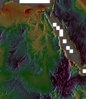
Figure 1: The study area, part 1
The provenance of Saharan sand is from the Tethyan Ocean, into which southern highland rivers also deposited large volumes of sediment and eventually from lacustrine/estuarine/fluvial systems which redistributed sediments on an uplifting passive continental margin. The missing link are the river systems that deposited and redistributed the sediment around the tectonically active North African basins. Palaeodrainage on a wide regional/continental scale down to local scale is, therefore, the focus of this project.
The understanding is that the tectonic geomorphology of the Sahara is that of the emergence of the southern continental margin of the Tethys Ocean – tectonics of both land and sea basins: a predominantly water-based environment. The arid landscape of today is the late (or current) stages of the geodynamic and climatic effects of opening oceans and continental collisions with the tectonic emergence of a continental shelf.
My suggestion, which is the hypothesis for this research project, is that a river system, from a lowland area around the Sudd, drained into the sea at the site of the Chad basin. Over time and changes in sea level and tectonics and shrinking of the Chad basin, a river system developed northwards towards the Sirte Gulf which followed a northward migrating coastline; the Sarir alluvial fan could possibly be a remnant.
Subsequent to tectonics and hotspot activity, particularly since the start of the Red Sea and EAR, this river system started migrating eastwards eventually forming palaeodrainage systems and lake systems west of the current Nile Valley and draining initially northeast to north, which was becoming affected by the collision of Africa with Europe.
As the Red Sea continued to open, thrust and shear faults as well as hotspots caused uplift, basins and doming, the older river valleys/lakes/estuaries and shallow sea coastlines were affected and drainage became chaotic, draining further eastwards into what would become the Nile Valley. The coastline possibly became a narrow seaway on the margin of an east-west southern basin with the uplift of an emerging Cyrenacean platform/plateau due to hotspot activity.
At this stage, the Nile was not connected to the Sudd. The suggestion is that the tail of the Nile was captured into the Sudd wetlands at a later stage of the formation of the EAR. Figure 2 summarises the ideas behind this research project.
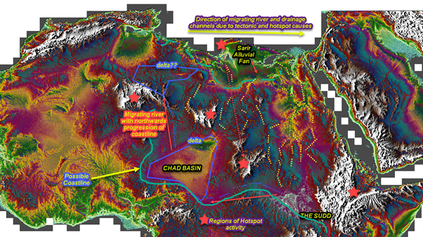
Figure 2: The hypothesis of drainage migration
Aeolian processes modified the initial water-based landscapes which have been continuing to this day.
This is the research project and the guiding hypothesis which will be a purely remote sensing project.
The research project to date
Digital elevation imagery
I created multiple digital elevation models (DEMs), using SRTM-30 data, over the last two to three years as a reconnaissance and regional geographic/geomorphological focus process. Whilst there were a few issues with initially creating them, the overall landforms suggested are fairly common across all DEMs I created. Figure 2 is one of the earlier attempts of North Africa. Whilst just an early trial at creating a continental scale DEM, this is useful as it provides a base to highlight my initial suggestions of North Africa being an emergent continental passive margin. These early trials for a DEM ultimately led to a methodology I refer to as Hillshade Normalisation.
Figure 3 shows the Sudd, and the N-NW trending deltaic form of floodwaters, towards the possible channel connecting the Chad Basin. The current connection with the Nile is weak and along an easterly trending sub-surface structure. There is a suggestion that an earlier N-S Nile channel may have existed to the east of the high landmass at the northwest end of the Sudd. It was this image and the surrounding areas that led me to conceive the current hypothesis.
The southern boundary of the study area, the Sudd Basin, is considered to be an earlier coastline or margin between upland and lowland. Everything from here up to the northern coast is considered by me to be a continental passive margin affected by both tectonic activity related to the collision of Arabia and the opening of the Red Sea, the collision of Africa with Europe and the intrusion of igneous complexes associated with both types of geodynamic events and related hotspot activity, which was variably fluviatile/lacustrine/estuarine/shallow sea dotted with islands and merging northwards into a deeper Tethys Sea.
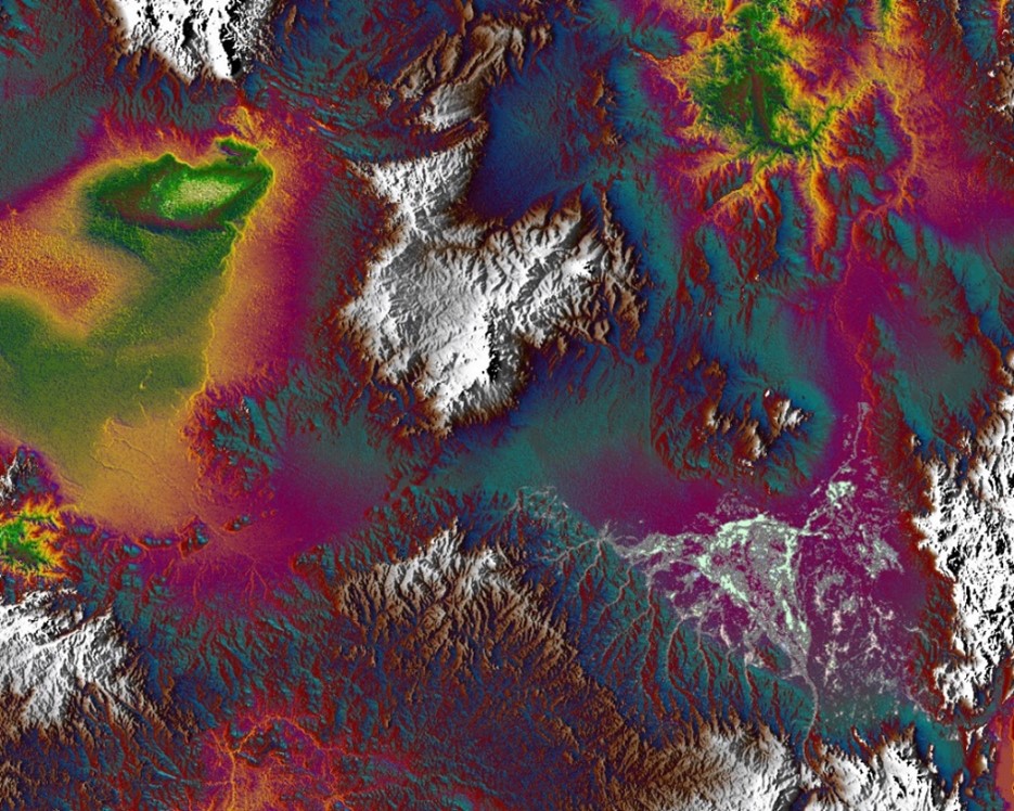
Figure 3: The Sudd and flood channels, lower right-hand side, with a possible connection to the Chad Basin, central left-hand side (green-yellow area)
Satellite imagery
As the Western Plateau seems to be a critical structural feature, I processed Landsat-8 OLI imagery over and around the plateau, where I have found that using a combination of individual PCA or ICA bands overlying the area might be useful in mapping the various landform and structural features (Figure 4). Mosaic creation does not currently work well due to too widely variable reflection from different scenes – temporal issue: couldn’t get satellite imagery over all the area at the similar time frames; widely variable.
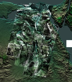
Figure 4: The northeast study area centred around the Western Limestone Plateau. DEM overlain with PCA/ICA processed Landsat-8 OLI
The next phase
To date all that has been achieved has been to develop a methodology, Hillshade Normalisation, of highlighting geomorphology and geological structure using SRTM-30 data to create a DEM and to process satellite imagery aimed to help support detailed interpretation, as well as spending two to three years looking at many features from which I have developed the working hypothesis.
The next phase is to focus on the intense and detailed analysis and interpretation of this large study area and creating a set of annotated image maps, Phase 1 being Northeast Africa. I am using the traditional method rather than looking at classification algorithms, as there are too many variable features that require identification and subtle variations that need to be considered.
Hexagon wishes Ted all the best as he continues his research! Learn more about how Hexagon supports universities and education here.
