Cloud-based solutions need no introduction. Public and on-premise cloud applications are omnipresent. The benefits in terms of cost, application delivery, etc. are clear.
In this blog, we’ll focus on the clients for accessing the data and applications available in the cloud. Browsers are an important set of clients, and typical programming languages are JavaScript and Typescript. For domains like defense, security, and emergency response, common operational pictures ensure collaborative planning and effective execution. Having a common operational picture available in a browser is a big benefit for military staff located at mobile headquarters, and for allied operations, as nothing needs to be installed on-premise.
A common operational picture requires some key capabilities. LuciadRIA is Hexagon’s browser-based solution for location intelligence and offers a Javascript and Typescript API with just the right tools.
Working off the same map
Good collaboration requires good mutual understanding.
First, everyone needs to look at the same map. Thanks to the standards provided by organizations like OGC, map data can be centrally managed and disseminated to systems, even if created by different organizations or vendors.
Depending on the command level or type of organization, people may be looking differently at the same data. In maritime, maps are typically looked at in the Mercator projection; in territory mapping, meanwhile, countries may use different projections for a variety of reasons (such as the country’s specific shape, for example). Some map servers provide reprojection of maps before serving them, but that feature may not always be available. Therefore, LuciadRIA not only connects to (OGC-compliant) map services, but also offers client-side reprojection to ensure that maps fit into your typical visualization.
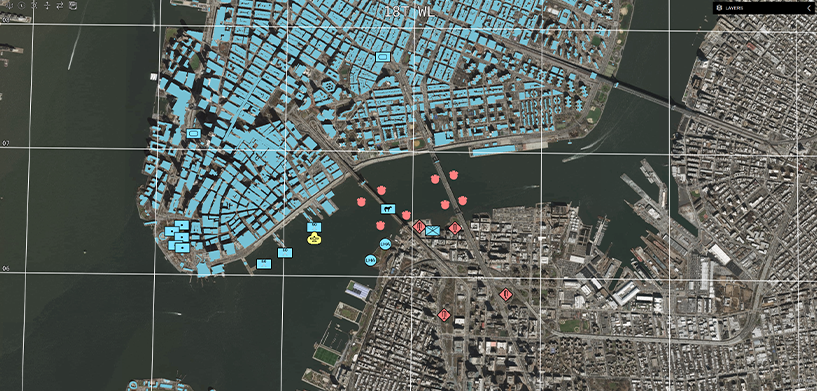
When multiple parties looking at the same map in different projections, communication about where exactly you are looking may lead to confusion. That is where grids come in handy, and LuciadRIA supports the MGRS grid. Overlaying this grid on your map allows convenient communication of grid cell names. And indeed, these grids can also be reprojected to fit your preferred map reference.
A common symbology
As early as the Napoleonic wars, allies recognized the need for an agreed symbology to talk strategy. For our customers in defense, LuciadRIA 2022.0 offers standalone support for the Mil-Std-2525 and APP-6 symbology standards. In addition, the API incudes extension points to add other symbology sets.
Web services can pre-render maps applying a given symbology. But when you receive data via feature service, LuciadRIA conveniently supports OGC symbology encoding — a standard for describing the feature and raster styling. Sharing a style definition ensures a common understanding of the relevant feature data.

Speed is key
For a common operational picture to be useful, operational data needs to be up-to-date. Are you looking for the fastest browser-based track display? LuciadRIA is what you need, and our customers have already done the benchmark to prove it. We offer a sample application to get you started.
Once you have up-to-date information filling your screen, you can do what humans do best: Aggregate and filter the data based on the attributes and criteria you defined to detect patterns and anomalies. Your organization expects you to act fast. LuciadRIA offers the tools to make it possible.
If you want to learn more about the new features in the Luciad 2022.0 release, take a look at this video.


