


Chris Hanni, a DigitalGlobe Foundation grant recipient and a graduate student from the University of South Florida, recently conducted valuable research on Texas Phoenix Palm Decline (TPPD). TPPD is a fatal, systemic disease that kills palm trees relatively quickly and is caused by a phytoplasma, or an unculturable bacterium that has no cell wall.
TPPD causes palm trees to turn yellow, lose their spears and fruit, and eventually die. The irreversible plant disease has been plaguing states such as Florida, Louisiana, and Texas for several years.
Hanni’s work on the project also led to him winning the 2019 HxGN LIVE EDU Contest. As this year’s winner, he will be presenting his work at the conference.
Using advanced remote sensing and machine learning technologies, Hanni aimed to provide spatial details regarding the severity of palm decline within the Golden Aster Scrub Preserve in Hillsborough County, Florida.
At the preserve, Hanni has been monitoring the phytoplasma Candidatus Phytoplasma palmae, which is threatening palm trees such as the Sabal palmetto, one of Florida’s keystone species that maintains ecological balance. His work could be used to provide influential data that can aid government agencies, forestry managers, and environmental advocacy groups in fighting TPPD.
Gathering and Analyzing the Data
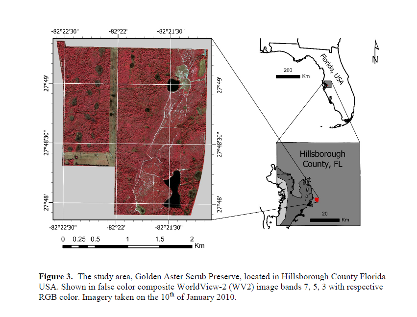
To begin, Hanni collected LiDAR data captured from an airborne Leica ALS-50 sensor. He also used three multispectral/temporal satellite images captured from the DigitalGlobe WorldView-2 satellite.
Then, the data was processed in ERDAS IMAGINE remote sensing software. Automatic tie points were generated and tuned manually through an iterative process until subpixel Root Mean Square Error (RMSE) was established. Automatic tie points were helpful in identifying general matching locations. The points were then scrubbed, turned, and regenerated with alignment on the digital surface model (DSM). It was paramount that a subpixel RMSE was generated for the Normalized Difference Vegetation Index (NDVI) change detection and canopy height isolation due to the small average tree canopy size relative to the 0.5-meter image resolution and the potential errors associated with misalignment, also known as slivering.
Then, he built a Rational Polynomial Coefficient (RPC) orthorectification block file construction. The orthorectification was paramount to this project’s success. This is because the tree crowns had to overlap within the four image layers, as overlap affects the accuracy of the NDVI temporal change calculations and canopy isolation.
The NDVI change was then used as the primary metric to assess general palm health outside the direct effects of anthropocentric disturbances for targeting areas having a higher probability of TPPD. This could then later be used in conjunction with ground samples confirmed with polymerase chain reaction (PCR) disease detection. The TPPD distribution sample percentage could then be applied as an estimate for the entire study area.
Later, he utilized the Spatial Modeler in ERDAS IMAGINE, which is used for building and running geoprocessing workflows, for the integral processes of canopy isolation, segmentation, feature generation, NDVI change calculations, and anthropocentric disturbance masking.
The ability to truncate or define a smaller processing area for model tuning with the adjustment of one parameter with Spatial Modeler significantly expedited the process of transitioning from test to full model deployment.
Concluding the Impact of TPPD on the Study Area
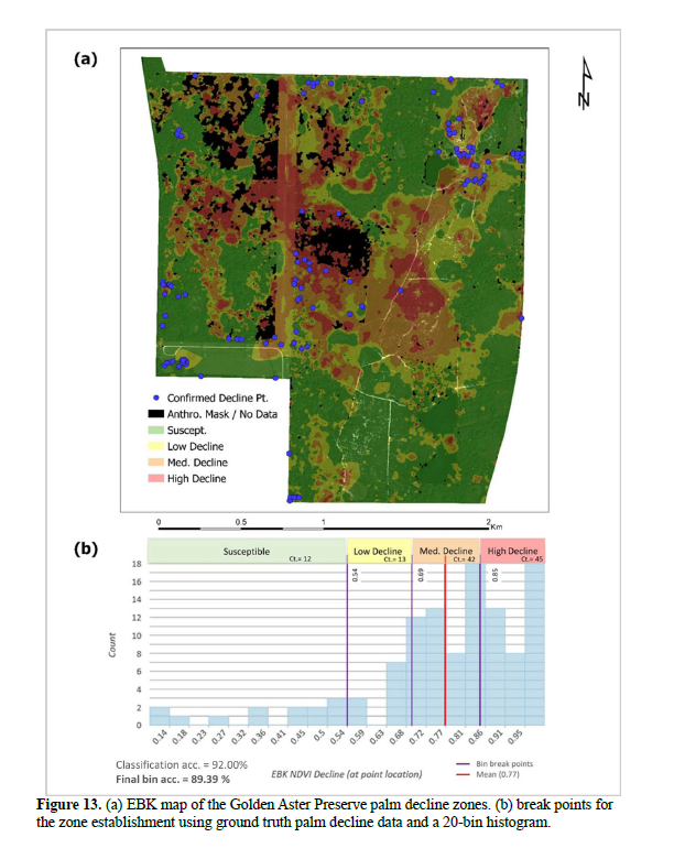
Hanni’s research displays a large portion of the study area exhibiting palm decline and provides a new methodology for deploying deep learning for multispectral satellite imagery.
Using TensorFlow deep learning classification, multiband spatial statistics and indices, data reduction, and stepwise refinement masking yielded a significant improvement over Random Forest classification in a comparative analysis. He recommends that the Sabal palmetto be elevated to an imperiled status to expedite funding for treatment and/or mitigation strategies.
During his project, Hanni found that the main advantage of ERDAS IMAGINE’s photogrammetry capabilities was the ability to handle multiple layers congruently while managing the x, y, and z control point data in a fashion that made individual layer selection and turning readily exposed to the user. Also, the spatial modeling function exceeded his expectations and provided the ability to introduce and develop subcomponents to address targeted and unforeseen issues, such as the introduction of the anthropocentric disturbance subcomponent within the model.
Thanks to Chris Hanni for his influential use of Hexagon software. We look forward to seeing the impact of his work on future initiatives aimed at preventing and mitigating the spread of TPPD.
Watch Hanni present his work in the video below, and see our website for more information on the Education Program.
