


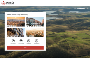
Choosing a travel destination can be overwhelming, but digital tools make it easier. Not only can tourists research locations they’re interested in, but officials in various locations can also share pertinent information with would-be visitors more easily than ever.
As with any process of digitalization, data is key to improving the travel experience. A pilot project carried out by the Badajoz Provincial Council in Spain, along with Hexagon and our partner Ayeria, recorded spatial information about visitors in October 2019.
COUNCIL TOURISM
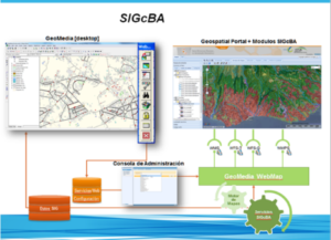
Badajoz has a geoportal called SIGCBA built with Hexagon’s GeoMedia Professional and GeoMedia Webmap tools. Via smart digitalization, the municipality has made it easy for users to access data, metadata, and infrastructure information.
To comply with European regulatory parameters, the portal covers environmental quality, accidents, noise reduction, and road space. As a secondary benefit, visitors can leverage this data to achieve greater enjoyment of their experiences in Badajoz.
Spain has served as a pioneer in developing global standards for tourism. Its digital transformation provides a roadmap for a new of tourist destination management that establishes objectives, goals and action plans linked to the four axes on which a Department of Trade and Industry is measured: innovation, technology, accessibility and sustainability.
Putting data to work
Big Data is crucial to the development of smart tourist destinations and adapting the designs of cities to the needs of tourists and residents. The tools in Hexagon’s portfolio enable officials to improve the tourist experience before, during and after the trip.
Pre-travel, Hexagon’s solutions boost the competitiveness and positioning of the destination. For the duration of a stay, the tools increase a location’s operational efficiency through the incorporation of innovation and data management. With an eye to the future, Hexagon helps cities and towns improve sustainability in three areas: environmental, social and economic. Universal accessibility and an increased quality of life for residents are added benefits.
Antonio López de Ávila is the president SEGITTUR, a Spanish society that exists to promote innovation and technology in the tourism sector. He has spoken on the importance of digitizing tourist resources and providing useful information before, during and after a trip. At the same time, he says, tourist intelligence systems should allow individual entities to include the data they need “to understand their city as a destination, see how each tourist moves and where they spend every moment.”
Mobility dashboards
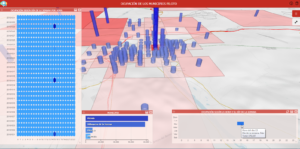
In Badajoz´s pilot smart application, mobility data is provided by Kido Dynamics and exploited by Hexagon’s geospatial tools. Results can be analyzed in the M.App Enteprise platform through different dashboards.
Occupancy by national tourists prorated by dates:
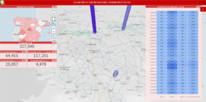
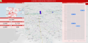
Because the application is so easy to use, it’s feasible to search even the most common queries and access the data independently by province.
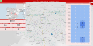
International occupations:
Based on a grid distribution, users can determine the number of hours that each visitor has been in each town. Relationships can then be established according to visitors’ nationalities.
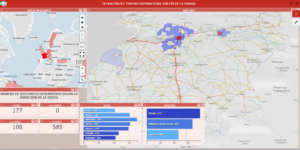
Analysis by date allows users to calculate the average duration of visits and determine a location’s popularity relative to the days of the week.
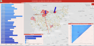
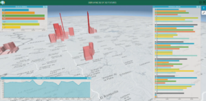
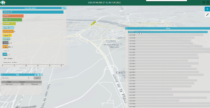
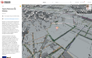
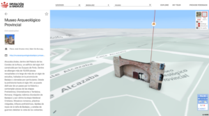
Studies of movements of people Cadastral 3D visualization
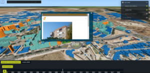
The data provided by the different municipalities has been complemented with free data from additional sources to expand functionality. For example, with powerful visualization tools like LuciadRIA, users can visualize information such as:
Real-time traffic Pollution studies

Points of interest
The possibilities are nearly endless with Hexagon’s Smart City solutions. With smarter visualization, analysis, and reporting, cities can make the most of their resources, optimize spending and prioritize work to ensure the best possible experiences for tourists and residents alike.
