


Many urban areas have increasingly experienced natural and manmade disasters due to climate change and aging infrastructure.
Around the world, cities have been affected by urban flooding. This is caused when heavy or prolonged rainfall overwhelms a community’s stormwater drainage capacity when runoff is channeled from roads, parking lots, buildings and other impervious surfaces to storm drains and sewers that cannot handle the volume. According to research from AGU, “Landslide hazard is most sensitive to precipitation variations in urbanized areas.” In fact, AGU posits that urban areas may be at greater risk for precipitation-triggered landslides than rural areas.
Also, explosions have rocked some older or developing urban areas. For example, in early 2021, a gas boiler caused an explosion in Madrid that left at least four people dead and destroyed a building on a historic street, EL PAÍS reported. In the U.S., Philadelphia Gas Works, a utility owned by the City of Philadelphia, is facing a lawsuit brought by the family of a man killed in a home explosion in 2019. The family says the utility “is moving at a glacial pace to replace old pipelines that put their relatives and city residents at risk.”
Compounding these issues, the world’s population is growing. The latest projections by the United Nations suggest the global population could grow to around 8.5 billion in 2030, 9.7 billion in 2050 and 10.4 billion in 2100. The UN also says that 68% of the world’s population is projected to live in urban areas by 2050. https://www.nytimes.com/2021/01/20/world/europe/spain-madrid-explosion.html
To address the increase in natural and manmade disasters, as well as prepare for growing populations, urban planners should turn to robust digital twins to effectively plan, manage and monitor their communities.
What is urban planning?
Urban planning directs the development and revitalization of towns and cities, informing policies and funding mechanisms that affect roads, buildings, utilities, parks, transportation and more. The U.S. Bureau of Labor and Statistics says urban planners develop land use plans and programs that help create communities, accommodate population growth and revitalize physical facilities. To do this, planners rely on data collection and analysis, forecasting, design, public consultation and the strategic goals of the municipalities or regions in which they work.
How do digital twins inform urban planning?
More than just a static 3D model, a digital twin of a city is a true, dynamic digital representation of a municipality and its infrastructure, buildings, roads and bridges, vegetation and more that is developed using sensors, GIS data, spatial information and other technologies. By bridging the physical and the virtual worlds, data is transmitted seamlessly, allowing the virtual entity to exist simultaneously with the physical entity. Because a digital twin is a replica of its physical counterpart, it can be used to detect incidents and anomalies and explore proposed changes or expansions to an urban landscape.
Urban planning using digital twin technology means that the status of a community’s entire infrastructure can be visualized in 3D, and when utility data is integrated into the digital twin, it becomes apparent where each asset, such as gas, water and electricity lines and installations, old and new, is located. This allows for the detection of needed revisions or updates before incidents occur.
Digital twins give urban planners an intricate view of the municipalities they manage and are invaluable tools for envisioning their futures. Not only do they show planners their communities in 3D, but they also allow them to play out scenarios before they enact changes in the real world.
Planning with a digital twin helps revitalize and build safer, more sustainable communities
Physical maps, images and building information models are just some of the data sources that contribute to a robust digital twin. Real-time and historical weather data and digital elevation models can also be used to better understand and predict natural incidents like flooding, landslides and more.
Once all building and infrastructure locations are mapped, predictive analytics can identify potential risks, and on-site remediation can be planned more accurately. The proper placement of sensors can be planned based on data flowing into the digital twin, so that early detection alerts or alarms can be implemented for C02 levels, temperature spikes or unauthorized movements, etc.
In locations such as industrial complexes, aging buildings, bridges and public transportation lines, a digital twin turns information into insights on safety, sustainability, traffic flow and impact, investment justification and more. With a digital twin, decisions become driven by data and planning is more cost effective, since different scenarios can be “implemented” digitally before decisions are made.
Learn more
Incorporating GIS, 3D and AI capabilities enables the development of a robust digital twin for effective urban planning. Hexagon integrations, analytics and mapping technology can help.
Click here to see how city leaders and officials can use Hexagon’s digital twin and AI capabilities to create better policies that affect housing, urban planning, mobility, climate change and more.
Contact us to learn more today.
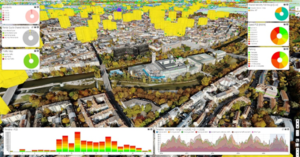
Example of dashboards based on historical urban planning information
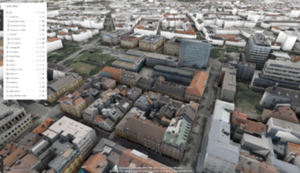
Example of 3D visualization of a city
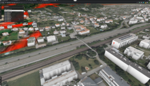
Result of analytics superimposed over a 3D model of a city
