


As the COVID-19 pandemic continues, its effect on the global agriculture industry will, too.
More specifically, you can expect to see changes in the way aid is provided to farmers and other agro-food actors to build long-term resilience within food and agriculture sectors. The Organisation for Economic Cooperation and Development (OECD), responsible for distributing more than 500 billion USD annually over 54 countries, is already working to understand that change.
The OECD committee recently released policy responses called, “The impact of COVID-19 on agricultural markets and GHG emissions.”
According to the document, “The COVID-19 pandemic has imposed a shock on agricultural markets and its effects will most likely reverberate throughout the coming decade. The macroeconomic impacts of the pandemic, such as the fall in household income, are leading to a decline in gross calorie demand, especially in LDCs (least developed countries). Further efforts will be needed to help end hunger and malnutrition by the end of the decade as the pandemic puts additional people at risk.”
Reduced demand and production will put even more pressure on organizations that provide aid to the industry to support farmers and, ultimately, global food production. The combination of different technologies from Hexagon’s Geospatial division allows funding agencies to generate final applications in the cloud that, through control panels, allow remote monitoring of plantations. These monitoring applications can be configured to determine where aid is needed most and even to award aid through the app.
Building Applications for Agencies and Farmers
By analyzing satellite images from different times of the year with ERDAS IMAGINE, users can locate plots by coordinates and see if they are cultivated or not. They can also change the different vegetation index models to differentiate the types of crops and thus determine eligibility for aid.
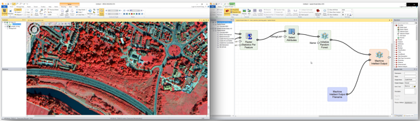
ERDAS IMAGINE and it´s workflow management through the Spatial Modeler tool displaying an easy example for Vegetation Index Calculation
These solutions can also be beneficial for Smart Agriculture. When repeating the same study in different periods, farmers can analyze the growth of the cultivated areas and make a productivity analysis and thus determine which areas are more suitable for each crop type. This can also be used by funding agencies to better understand how their funds are being used.
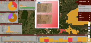
Smart application on the cloud (using M.App Enterprise) for monitoring changes of crop growth in different periods
Conducting additional studies in a 3D view with digital terrain models, farmers can analyze drainage and humidity degrees and optimize irrigation. The fertilization analysis allows them to properly apply the different components to each crop to prevent diseases and produce greener products.
As these results reach the end users, they are able to better control crops and fertilization.
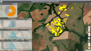
Another smart application using M.App Enterprise for pest and fertilization monitoring
Never before has it been so easy to control plantations and distribute aid to farmers who need it.
You can see more examples of Hexagon solutions for agriculture on our website.
