


Government agencies responsible for taking care of the environment face a great challenge: to continuously monitor activities in forest areas, with the goal of automatically generating deforestation alerts when certain conditions are met.
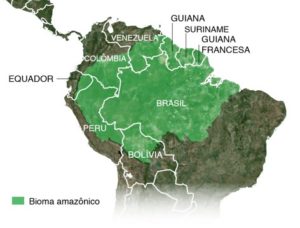
When the areas to be monitored are small enough, this task can be straightforward, but to monitor large biome areas such as the Amazon rainforest, which covers more than 5,000,000 square kilometers, the challenge is immense — especially when there is a need to get rapid answers and make quick decisions.
In solving this problem, there are two important components to consider:
- Data type: the ideal data for this task is satellite imagery covering large territorial extensions that can be collected regularly
- Technology: the best systems for the job are autonomous and can detect changes through automated processing flows
Hexagon Geospatial offers a unique geospatial platform that allows users build a complete architecture within the image processing cycle that detects deforestation and issues alerts in a fully automatic way.
The solution, to be proposed to the government agencies related to monitoring and inspection, provides the following benefits:
- greater efficiency and agility in decision making
- reduced infrastructure and human resources cost for field work visits
- better organization of the types of data to be used within the operating environment
- ability to use of any type of input imagery, either commercial or free use, that reaches a certain level of quality and reliability
Data types and their characteristics
Nowadays, there are plenty of types of satellite sensors that allow efficient data collection with frequent updates and complete territorial coverage.
Each sensor has its own characteristics and different uses. What decides which type of sensor to use for a continuous monitoring process is the type of object or target to be monitored — that is, water reservoirs, irregular deforestation, irregular mining areas, urban expansion, etc.
In the case of detecting deforestation, free satellite images can provide an excellent first layer of information to environmental monitoring organizations, which can then, in a second evaluation stage, make use of high-resolution commercial images.
In order to monitor large forest areas and regions where there is a high level of cloud cover, as it is the case of the Amazon, which is located in a tropical region, it is necessary to use radar satellite images. Radar satellite images can be collected under any weather conditions, day or night, and have excellent accuracy for detecting changes.
To detect deforestation with an automated workflow, images from the Sentinel 1A and 1B satellite of the Copernicus space program (managed by the European Space Agency) have been employed.
Automated processing workflows
Using Hexagon Geospatial’s platform, it is possible to define an automated processing workflow with quick response and analysis capabilities. The automated workflow also minimizes manual operations, which are always subject to errors.
The workflow developed for the Amazon performs various processing steps, including co-registering the images, suppressing noise, coherence change detection, classification, filtering, converting from raster to vector, and inserting the vectors into the database.
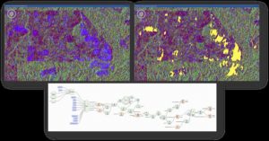
The following image is an overview of one of the workflows developed with the Spatial Modeler tool of Hexagon Geospatial’s ERDAS Imagine product:
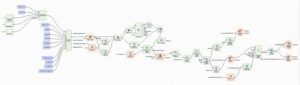
Spatial model to extract changes using SAR images.
In this spatial model, there are several processing phases; when all of them are integrated into a single workflow, it is up to the experts to evaluate and validate the outcomes that are extracted from the images. In this case, the results are areas of changes that can be classified and identified as areas of deforestation. These areas are considered alerts to be evaluated by the inspection teams.
Architecture
Within the context of an intelligent monitoring workflow, it is natural to have several workflow steps like data collection, organization, processing, dissemination, visualization, and integration. With Hexagon Geospatial’s tools, it is possible to propose an architecture that can perform all these steps and allow government agencies to have a fully integrated, autonomous system.
Below is an example of a complete architecture used by Hexagon Geospatial’s customers who need to perform continuous monitoring tasks in a fully automated way.
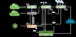
Sample of architecture for autonomous image processing.
Results
Several results can be obtained through digital image processing techniques using the automated workflows available in the Hexagon Geospatial’s tools. All of these results can be used as parameters for a more punctual analysis to be carried out by specialists when doubts arise. Thus, specialists can validate the alerts identified.
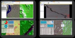
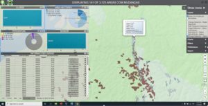
Different results can be seen in different interfaces.
The final results provided in processing chain are polygons automatically extracted from comparing time-based images.
Yellow polygons represent changes in a temporal analysis,
Powered by M.App Enterprise, the application is easy to use and can be targeted to non-expert users. It is an analytical and environmental web application based on Feature Analyzer that allows users to perform geo-temporal queries over the alerts generated by the system.
Comparing radar vector and optical vector extractions,
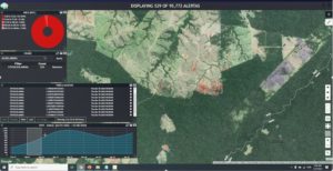
Analytical view showing temporal alerts that were extracted from radar images.
Here, is possible to see the areas that were extracted automatically from radar images compared with other areas extracted from optical images. This is a double check to verify the precision of radar image traction. With an analytical view, it is possible to present a location intelligence panel showing the past and present situations of deforestation.
Conclusion
A smart monitoring solution based on Hexagon Geospatial tools using automated processing workflows allows governmental agencies responsible for monitoring the environment to achieve their goals. Greater speed and efficiency in the dissemination of information and field validation leads to higher quality data and more trust in the provision of information.
Continuous monitoring allows predictive analysis to identify areas of concern to the operational and strategic challenges of a corporation with increasing accuracy. Such monitoring can work with different types of sensors, guaranteeing that the solution will meet not only a single analysis demand, but all digital image processing demands.
Among the organizational benefits Hexagon’s tools can provide are faster generation and dissemination of information, integration of various workflows and processing, and savings on system and hardware infrastructure investments. Learn more about how Hexagon technology empowers Smart Nations.
