


At the end of each year, everybody loves to check out lists of the best and worst movies, songs, apps, must-reads, memes – you name it. Well, here’s a list of our five favorite virtual Hexagon events of 2020!
1) The Importance of Real-Time Location Intelligence to Effectively Manage COVID-19 and Other Humanitarian Crises
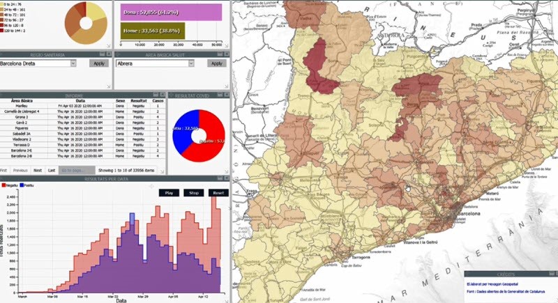
As the COVID-19 pandemic has impacted not only public health, but also public life and the economy around the world in 2020, this webinar explains that if you can’t map it, you can’t manage it. Because the resources of government authorities and public services are limited, geospatial technology can help these organizations manage their response to the COVID-19 crisis and other humanitarian disasters and better inform and engage with citizens.
2) Oil Palm Mapping
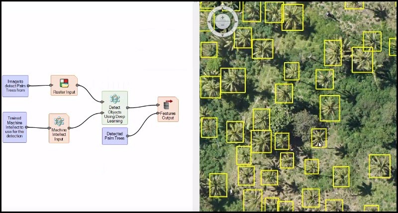
Machine learning layout tools can be used to detect a multitude of natural and man-made objects. In this tech talk, learn how to ERDAS IMAGINE was used to identify and map oil palm tree locations in RGB orthophotos. Image detection saves time and manual labor, and it’s just one of the ways ERDAS IMAGINE’s consolidated workflows, smarter processing, and dynamic modeling can work for you.
3) Smart Forest Management and Monitoring

Forests cover nearly a third of the Earth’s land surface, providing timber, food, fuel, storage and recycling of water, habitat for a variety of plants and animals, and recreational benefits. But threats to the world’s forests are growing. Expanding agriculture methods, illegal and unsustainable logging, wildfires, and development pressures are some of the major dangers to forests globally. Watch this session to discover how forest agencies are working to monitor and preserve these rich and diverse natural resources.
4 ) Rapidly Sharing and Visualizing Real-time Multinational Geospatial Co-Production Data
In today’s constantly changing military environment, it is critical for coalition forces and non-technical users to help create and leverage a modern, up-to-date, and globally available digital database for geospatial information and location intelligence. Watch this webinar to discover how digital and near-real-time mapping is transforming military operations.
5) Location Intelligence in Transportation
![]()
In this presentation, Bruce Chaplin highlights the scale and scope of transportation in North America – and some of the big picture challenges that those in the industry are facing. He discusses three customer stories in road transportation: one about planning, one about operations and maintenance, and one about safety.
Transportation, defense, forestry, public health services — these are just some of the amazing applications Hexagon technology was used for in 2020. As we look forward to 2021, we can’t wait to see what new ideas and innovations will emerge.
Interested in joining us for future events? Check out our events page!
