


Hexagon’s Geospatial division is pleased to have extended our offerings for our listing on the G-Cloud 12 framework within the Digital Marketplace of the Crown Commercial Service (CCS). With this listing, customers within the public sector in the UK will have easier access to Hexagon’s leading geospatial software and services.
Last year, Hexagon was listed on the G-Cloud 11 framework with a number of software and service offerings. The additional software listed on the framework this year from Hexagon gives user organisations greater capabilities in data capture, information extraction and data utilisation across their enterprise. They are:
- Smart M.App – lightweight, targeted map applications that help solve real business problems. Combine multi-source content, sophisticated analytics and tailored workflows in a dynamic user experience across mobile, browser and desktop.
- Mobile Alert – citizen and workforce reporting application for reporting incidents, issues, or work-related details right from a free mobile app. Enables community empowerment with feedback about reports and their status.
- M.App X – Enterprise solution that fosters geospatial tradecraft creation, common usage and secure sharing of intel, ultimately making the latest information accessible and reusable within organisations.
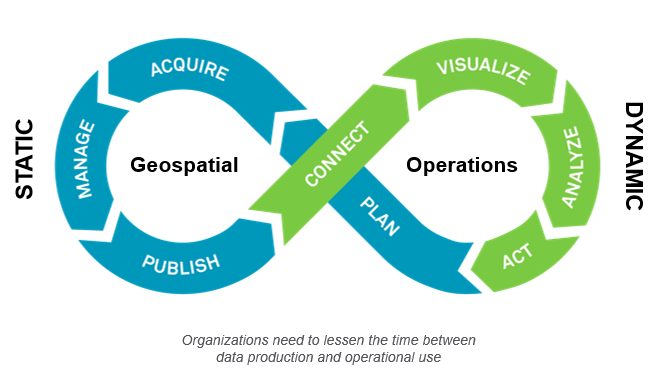
With the existing software listed on G-Cloud, Hexagon now offers APIs, platforms and products, all hosted and deployed via cloud infrastructure. This comprehensive range of software provides the tools to visualize, analyse and derive insight from location information to solve mission and business-critical problems. Using Hexagon technologies, organisations can shorten the time from geospatial data acquisition to insight-based action within their operations, solving the Geo-Ops challenge.
Training, Consultancy and Development through the G-Cloud 12 Framework
Hexagon’s G-Cloud offerings in the Cloud Support categories include:
- Training GIS & Geospatial Software – Certified trainers share their expertise with software professionals who develop projects using Hexagon technology. We familiarise training participants with best practices in geospatial application development and with Hexagon’s product philosophy.
- Consultancy for GIS & Geospatial Software – A team of consultants can be hired to assist you in building your solution using Hexagon products. They aid in the creation of diverse solutions with real-time data and analytics capabilities.
- Custom Development for GIS & Geospatial Software – A team of experienced engineers can assist the build or customisation of your solution using these products. These products are especially applicable for the creation of diverse mission-critical applications.
For more details about Hexagon’s listings, visit the Digital Marketplace.
Hexagon is a global leader in sensor, software and autonomous solutions. Hexagon’s Geospatial division’s offerings include cloud-based platforms and solutions that deliver location intelligence, combining geospatial data with real-time data visualisation and analytics for industries that include defence, smart city, aviation, maritime and transport.
