Hexagon’s Geospatial division has released M.App Enterprise 2019. An ideal platform to monitor assets, evaluate changes, and take action, M.App Enterprise is a privately-hosted solution that allows organizations to deploy Hexagon Smart M.Apps that dynamically address their location-based business problems.
This latest version of M.App Enterprise unites the best of both worlds by integrating capabilities from Hexagon’s Luciad Portfolio to enhancing data visualization, analytics, and management. It also adds several machine learning-based classification operators from the integrated Spatial Modeler, our graphical interface for building and running geoprocessing workflows in select desktop products. This allows users to experience a 5D smart digital reality, where data is connected seamlessly through the convergence of the physical world with the digital and intelligence is built into all processes.
See M.App Enterprise 2019 in Action
Does all of this sound too good to be true? Have a look at the video below, featuring the Alps. You may remember the Alps from the tale “Heidi, girl of the Alps”.
In the story, Heidi spends her summer days on the mountain top together with Peter the goatherd, whose responsibility is to take the villagers’ goats to the high mountains for pasture. In order to find the best spots for his goats to graze, Peter could definitely have benefitted from the following M.App Enterprise-based application that was developed for AgrarMarkt Austria, or AMA.
AMA receives about 1.5 billion EUR from the European Union to fairly divide among 150,000 farmers in Austria who have submitted a funding request. Land area is a deciding factor for granting funding requests to farmers, but in the past some of the requests included land that couldn’t actually be used for farming, such as rocky or tree-covered areas.
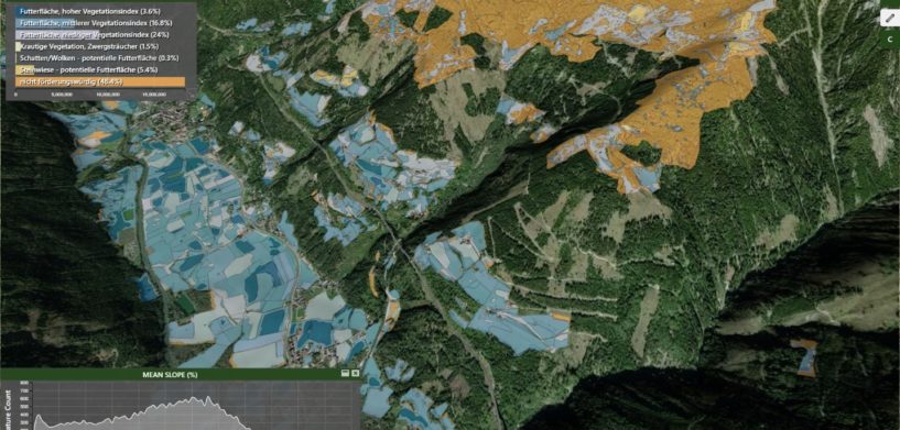
Enter M.App Enterprise 2019. In the example of cattle grazing, there are two factors that would influence whether or not a subsidy is given for a parcel of land fit for grazing: the vegetation and the slope associated with the parcel. Both of these elements can now be identified with the new features from the M.App Enterprise release.
In the application, vegetation is defined with the new machine learning capabilities. The model automatically extracts over 36 types of vegetation from satellite data, including trees, low vegetation grass, and so forth and visualizes these on a Smart M.App. Since cows (or Peter’s goats) do not eat trees or rocks, it’s easy to define which areas do not warrant getting a subsidy because they are covered by non-vegetation, which we see from the Smart M.App.
Slope is another deciding factor for getting a subsidy. Cows (or Peter’s goats) can’t graze on 45 degrees of slope. With the new 3D capabilities realistically visualizing the terrain, there’s no longer any doubt about that!
See what else to expect in the M.App Enterprise 2019 Release Guide.


