


In today’s interconnected world, border security is an increasingly complex challenge that requires innovative solutions beyond traditional physical barriers like walls and fences. Modern borders also encompass virtual boundaries defined by geopolitical, economic and technological factors, relying on sophisticated monitoring systems and geospatial technologies to detect and manage threats. The interplay between hard and soft borders adds complexity to security operations, necessitating advanced tools for detection, analysis and response.
Hexagon offers two complementary solutions to address these evolving risks: the Luciad and HxGN dC3 portfolios. Luciad is ideal for general border protection, providing comprehensive geospatial solutions that enable real-time situational awareness and seamless data integration across vast and varied terrains. In contrast, HxGN dC3 is designed for sites with high security requirements, such as border crossings and critical infrastructure, offering specialised tools for enhanced perimeter security.
Explore Hexagon’s defence solutions

The area in red is protected by sensors. If an unidentified drone enters that zone, an alarm is triggered.
Challenges of modern border and perimeter security
Border security operations face unique challenges:
- Monitoring vast areas: Borders span thousands of miles across rugged terrains, deserts, forests and waterways, making real-time monitoring challenging
- Managing cross-border threats: Smuggling, unauthorised crossings and drone incursions require rapid detection and response
- Integrating disparate data sources: Security operations rely on diverse data streams, including surveillance cameras, drones, satellites, intelligence and IoT sensors
- Achieving real-time decision-making: Immediate action is often required, demanding up-to-date information and tools for informed decision-making
- Adapting to evolving threats: New risks like cyberattacks and drone-based smuggling require flexible, adaptive solutions
Traditional systems like fencing and CCTV cameras are insufficient. Advanced technologies like LiDAR, geospatial analytics and AI are essential for modern security operations.
Geospatial solutions: A game changer for border security
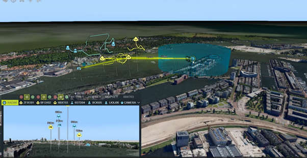
Various radar and video feeds are integrated in a single view, with military symbology and 3D visualisation. A geospatial overview shows drones flying in a 3D model of a city. Those shown in blue are “friendly.” Those shown in yellow are unknown. Inset is a video feed from one of the drones in which we see what the drone is seeing. In the overview, we also see the radar installation in the blue/green area.
Geospatial solutions revolutionise border security by enabling real-time situational awareness and seamless data integration. Hexagon’s Luciad portfolio is a powerful suite of geospatial solutions, enabling efficient data management (LuciadFusion), advanced geospatial desktop applications (LuciadLightspeed), browser-based tools for remote teams (LuciadRIA) and mobile capabilities for field operations (LuciadCPillar) to meet modern border security demands.
Addressing border security challenges with Luciad
Luciad provides a foundation for tailored applications addressing modern border security challenges:
- Monitoring vast areas: Integrates data from sensors for real-time views of expansive regions
- Managing cross-border threats: Supports dynamic geofences that trigger alerts upon breaches
- Integration of disparate data sources: Acts as a data integration hub, harmonising diverse data formats
- Achieving real-time decision-making: Ensures access to up-to-date information for coordinated decision-making
- Adapting to evolving threats: Enables adaptation to new threats through flexible application development
Together, these solutions empower border security agencies with unparalleled situational awareness and operational efficiency, ensuring preparedness for future challenges.
HxGN dC3: Transforming perimeter security
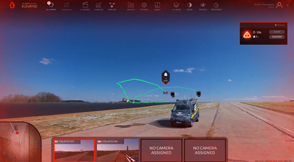
With HxGN dC3, you can track and trace the trajectory of rogue drones.
HxGN dC3 is an advanced software portfolio designed to tackle perimeter security challenges at sites requiring high security. to this approach are the video management software HxGN dC3 Video as well as the 3D surveillance solution HxGN dC3 LidarVision, which uses LiDAR technology and AI for enhanced detection, object classification and continuous tracking. Unlike traditional systems focused on fence-line monitoring, LidarVision secures entire sites, including detecting drones up to a certain flight altitude. It creates adjustable virtual zones, allowing for flexibility during maintenance while maintaining security. Integration with cameras, alarms and speaker systems ensures a unified response.
A notable LidarVision success is EG.D in the Czech Republic. EG.D uses LidarVision to secure high-voltage transformer substations, achieving real-time tracking and improved safety and efficiency. As a result of the pilot’s success, EG.D and Hexagon are working together on a plan to roll out LidarVision to other energy facilities across the grid.
Complementing LidarVision is HxGN dC3 Video, which integrates video surveillance with analytics for object detection and forensics. At the core is HxGN dC3 Orchestrator, a PSIM software that unifies diverse security systems into a single platform, enabling seamless transition from detection to coordinated response.
Learn more
Hexagon technology redefines border security by addressing specific challenges in perimeter and border protection. HxGN dC3 revolutionises perimeter security using LiDAR technology, digital twins and real-time tracking to enhance safety and efficiency. Meanwhile, Luciad tackles border security challenges with geospatial solutions, enabling real-time data integration, visualisation and mobile situational awareness. These tools help agencies monitor remote areas, respond to threats and adapt to evolving risks. Together, they provide a comprehensive and adaptable approach to safeguarding borders and critical infrastructure, ensuring resilience in an ever-changing security landscape.
Explore Hexagon’s defence solutions

Christophe Plevoets is a product marketing manager specialising in geospatial solutions at Hexagon. He has been a pivotal team member since 2018. He has a rich background as a customer consultant, presales specialist and business development engineer, and he has honed his expertise in geospatial technologies and strategies. His diverse roles have equipped him with a comprehensive understanding of customer needs and market dynamics. This enables him to drive innovative marketing initiatives that enhance Hexagon’s geospatial offerings. Passionate about leveraging cutting-edge geospatial technology, Christophe is dedicated to empowering businesses to make informed, data-driven decisions.
