


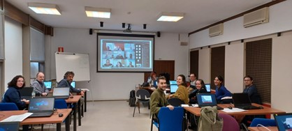
Throughout February and March, Hexagon’s Safety, Infrastructure & Geospatial division hosted several workshops at the National Geographic Institute (Instituto Geográfico Nacional, or IGN) in Madrid. These workshops explored the new functionalities and advantages of Hexagon’s GIS product portfolio, which is used at the institute.
Attendees had hybrid options, with in-person workshops at IGN at Ibañez de Ibero in Madrid, as well as virtual attendance throughout Spain, including Andalusia, Aragon, Asturias, Castilla y León, Castilla-La Mancha, Catalonia, Extremadura and Galicia. The workshop held at IGN saw more than 10 provincial delegations actively participating.
In one workshop, Hexagon experts demonstrated GeoMedia Professional and how improvements to the product can be applied practically to workflows at IGN.
In another workshop, we demonstrated ERDAS IMAGINE remote sensing and photogrammetry tools. Hexagon experts discussed best practices IGN users can employ to optimize the technology and better define the use of its licenses.
Automated workflows are the key to obtaining greater productivity and automation for IGN, which is why a section of the workshop was dedicated to the use of Spatial Modeler, a C++ toolkit for building, modifying and running workflows on geospatial data.
Hexagon is committed to helping its customers and partners be successful, with efficient and reliable technologies that meet their needs.
Hexagon and IGN
Hexagon and IGN have been working together for more than 30 years, experiencing the transformation of technologies and IGN departments.
Hexagon has been involved with IGN since the beginning of its creation of different map series and cartographic databases, at different scales from 1:25000, to 1:2000000, regional cartography and other maps of interest.
Other IGN departments work with Hexagon remote sensing technology for land usage classification and photogrammetry to create digital terrain models (DTMs), digital surface models (DSMs) and orthoimages (orthos). Regional departments are also involved in the creation of the IGN’s global database.
 Bego Verdejo holds a degree in topography and geodesy from Universidad Politécnica de Madrid, with several master’s degrees in GIS and remote sensing. She has been with Hexagon for more than 33 years, working in presales, support, training, product management (photogrammetry), publications and transportation. Her focus is now on radar technologies. For the last 10 years, she has worked for presales in EMEA, North America, Canada and Latin America. In 2022, she moved to government, transportation and defense, working mainly on urban digital twin projects and supporting African customers. She collaborates with R-evolution, Hexagon’s sustainable and green-tech investment subsidiary, and is mainly involved in projects such as solar, wind and forest preservation.
