


Whether you were in Australia or on the other side of the planet, you almost certainly heard about the continent’s Black Summer.
The fitting moniker refers to Australia’s 2019-2020 bushfire season, which was notably worse than previous seasons. According to Statista, 34 people died from the fires, and nearly 3 billion animals were killed or displaced.
Fires are a global concern affecting the health of people, wildlife, and the future of our planet. So what if you could map the risk landscape of fire? Even better, what if you could take proactive steps to keep the flames at bay?
Together, Hexagon and our partner GEO Data Design, a South African geospatial solutions provider, have taken fire risk mapping from the environmental wish list to a real and powerful solution that provides reliable data for fire mitigation.
Proactive risk management backed by undeniable data
Using the Prometeo algorithm from GEO Data Design, Hexagon’s smart monitoring solution of fire risk takes the guesswork out of determining fire probability. Built on Hexagon’s M.App Enterprise platform, this solution offers automated geo-analytics on vegetation fire risk related to assets.
The cloud-based M.App Enterprise platform allows you to easily monitor real-world changes, evaluate their impact, and act on the results. With the platform, you can create and access Smart M.Apps, or dynamic geospatial apps that help you solve industry challenges with real-time answers accessible from any device.
Within the smart monitoring solution of fire risk, data is updated every month, and you can access the data whenever you need from a web browser. The process is simple:
- Identify areas of high fire probability. The Prometeo algorithm calculates fire probability in an area of interest based on weather and climate data, satellite imagery, topography, and more.
- Monitor vegetation condition change. The solution features a fire probability dashboard providing continuous risk monitoring with real-time updates, interactive charts, and a 2D/3D map view.
- Integrate workflows for vegetation management. Manage your field crew and give them access to the platform from their mobile devices, even without internet access.
The solution has unlimited potential, whether that’s in environmental monitoring agencies or within industries like mining, oil & gas, agriculture, and urban planning. With one solution, decision-makers have the power to save lives, resources, and property.
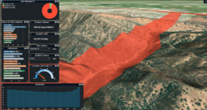
A real-world use case: transmission lines in Australia
Watch the short demo below, showcasing results from the solution along transmission lines.
In the demo, the M.App Enterprise-based business intelligence dashboard displays metrics to power decision-making for the supervisors of each area of the line. The dashboard features include:
- Data filters to answer specific questions about the areas of interest
- Associated costs for vegetation clearing that could lower the fire risk
- 3D capabilities to provide a more detailed inspection of the landscape
Want a closer look at how fire risk monitoring can reduce the probability of electrical fires impacting people and wildlife near the network? Watch our free on-demand webinar, Smart Monitoring for Wildfire Mitigation in the Electrical Supply Industry.
