


A menace that damages human skin on contact and is difficult to eradicate is plaguing rural citizens across the globe. Phototoxic plants in the Hogweed family, including giant hogweed (Heracleum mantegazzianum) and Sosnowsky’s hogweed (Heracleum sosnowskyi), are major concerns for many citizens and their local governments.
Giant hogweed, which can grow up to 14-feet (4.26 m) tall, is native to the western Greater Caucasus Mountains in southern Russia and Georgia, according to the Invasive Species Compendium. However, it is established and spreading in areas such as northern Europe, Canada, the U.S., Australia, and New Zealand.
Both hogweed plants exude sap that can burn, blister, and permanently scar skin, as well as cause blindness. In the summer of 2018, a teenager in the U.S. state of Virginia accidently touched giant hogweed while landscaping. The contact resulted in severe peeling and blistering on his face and arm. He also received medical orders to avoid sunlight for up to six months, along with a diagnosis of up to two years of light sensitivity.
Before government organizations can attempt to eradicate the hogweeds in their municipalities, they first must know where to look. The reporting process can be time-consuming; if a citizen notices a hogweed stand in a nearby field, they have to either call their municipality or visit the department in person to notify them.
With Hexagon’s Smart M.App Technology, local governments now have a more modern and streamlined way to work together with citizens to eliminate the hazardous plants.
Simplifying the Way Citizens Report Hogweeds to Local Governments
A new Mobile Alert Smart M.App called Zwalcz Barszcz (pronounced “zvulch burshch”) lets municipalities gather crowdsourced data about hogweed stands directly from citizens. Mobile Alert is Hexagon’s crowdsourcing platform for encouraging e-Participation. The platform supports transparency and enhanced collaboration between citizens and their governments.
The data gathering begins with the citizens. Using a free mobile app, they can take a picture of a hogweed stand, add any relevant data, and send it directly to decision-makers.
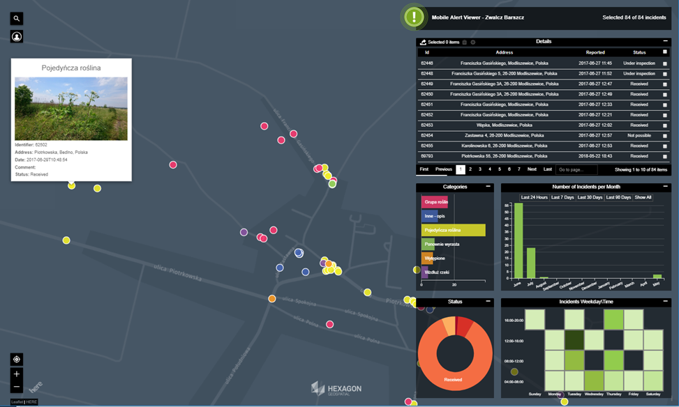
Reports through the mobile app appear in a common database. The government department can immediately see the reports through an interactive dashboard map view of the municipality. This holistic display helps the department to decide how best to move forward with their efforts.
Citizens can not only report new hogweed stands, but they can also keep officials updated on the results of herbicide treatment of nearby existing stands. In the mobile app, they can indicate whether an existing hogweed stand is dead or has resprouted. By viewing this data on temporal charts, departments can see the effectiveness of weed control initiatives for their governing area.
How It Works: Mobile Alert Smart M.App Technology
The Zwalcz Barszcz Mobile Alert Smart M.App was developed with Hexagon’s Mobile Alert Bundle of applications. The Mobile Alert Smart M.App Bundle includes the Mobile Alert Configurator and Mobile Alert Viewer Smart M.Apps.
With Mobile Alert Configurator Smart M.App, the user specifies the types of crowdsourced data they want to receive. The app is fully configurable, with options ranging from naming reporting categories to specifying the geographical reporting area.
With Mobile Alert Viewer Smart M.App, the user can see all of the crowdsourced reports in the dashboard view. They can also filter reports by category to gain tailored insights.
The Zwalcz Barszcz Mobile Alert Smart M.App, created by Geospatial Division Engineer Tomasz Glowacki, comes already configured to deliver the insight necessary for detecting and monitoring hogweeds. Government users who subscribe to the Zwalcz Barszcz Smart M.App can view their crowdsourced data in the Mobile Alert Viewer Smart M.App.
The process is simple:
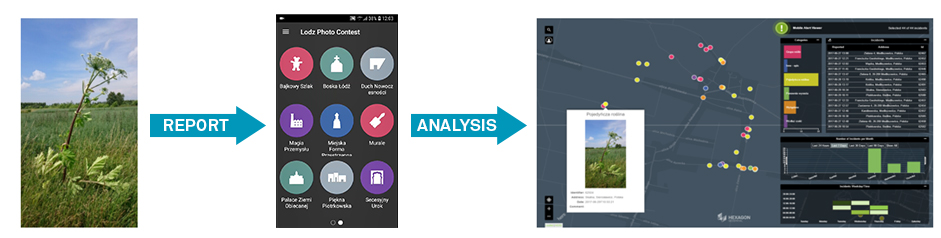
- Citizens download the free Mobile Alert mobile application from a mobile app store such as the Google Play Store or Apple’s App Store.
- Once they launch the app, they select an appropriate category for the report.
- They then capture or upload a photo. The GPS in the smartphone tags the photo with the location.
- They can enter optional information about the incident.
- If needed, they can use a map to fine-tune the location of the report.
- Once the incident is submitted, the appropriate department in the subscribing organization receives an email with the details.
- In addition, the report is also available in the Mobile Alert Viewer Smart M.App. This interactive dashboard view provides powerful tools for viewing and analysis.
The Zwalcz Barszcz Mobile Alert Smart M.App is currently being introduced to Departments of Environmental Conservation in areas highly affected by hogweed plants. The hope is that together, governments and their citizens can rid their lands of these dangerous plants.
Learn more about the interactive data viewing experience provided by Mobile Alert Smart M.App technology.
