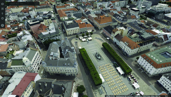
The City of Klagenfurt, the capital of Carinthia in Austria, recently created a “digital twin,” a technological advancement that’s expected to revolutionize the city’s urban planning, leaders said.
The digital twin, created using HxDR and M.App Enterprise software from Hexagon’s Safety, Infrastructure and Geospatial division, incorporates 19,000 individual images taken during a four-and-a-half-hour flight over the city at an altitude of 1,200 meters, officials said.
Klagenfurt’s urban planning department called the 3D model of the city a “digital milestone” with a level of detail unique in Austria, according to a report from the news site ORF.at.
“On the basis of this digital twin, we want to plan and implement a sustainable, livable and even more lovable city,” City Councilor for Urban Development Mag. Corinna Smrecnik told ORF.at.
The digital twin, using artificial intelligence, maps the total area of properties with different land use categories to better understand how properties within the city are utilized. The 3D model shows how valuable individual plots of green space are for the urban area’s climate.
The application also provides initial information to assess if photovoltaic and solar thermal systems can be installed on building surfaces. Roofs generate substantial solar yields from incoming solar energy and are shown in 3D with color representation indicating the level of energy yield. This information is used by the Solar Potential Cadaster of Klagenfurt, allowing residents to analyze if they can install a solar power system on their roofs.
The digital twin goes as far as calculating the effect of the shadows cast by each individual tree, in summer and in winter, to give a precise calculation of the solar energy potential of each Klagenfurt home and business.
“For each point, the energy input was calculated over the year, taking into account the atmospheric conditions and the shadows cast, and then a mathematical optimization calculation to determine how many panels can I get on this free space on the roof,” Dipl. Ing. Günter Koren, head of the Surveying and Geoinformation Department, told ORF.at.
The digital twin, which has been in development for a year, became available in mid-April on the city’s website, free of charge to the public and businesses.
To preserve data privacy, moving objects, such as cars and people, are not represented in the digital twin.
To read more about Hexagon’s digital twin solutions, visit https://hexagon.com/products/m-app-enterprise


