


What do you do when your map server just isn’t cutting it? You take a look at the competition to see what you may be missing.
This was the case for a European company building a Maritime Surveillance System whose employees were using an open-source map server solution to publish ECDIS maritime data. Because they found many shortcomings in this open-source solution, such as unacceptably slow performance, these employees began testing it against Hexagon’s LuciadFusion.
ECDIS is a computer-based navigation system which is used to visualize digital nautical data, and nautical data includes all information which may be of assistance for the safe navigation of vessels at sea and harbors, such as sea depth information, positions of buoys, lights, wrecks, and so on.
Big differences between the open-source solution and LuciadFusion immediately became apparent while working with the ECDIS data. The employees contacted the Presales team in Hexagon’s Geospatial division to understand those differences. One of their first questions was, “Why are the lines curved in LuciadFusion’s published output?”
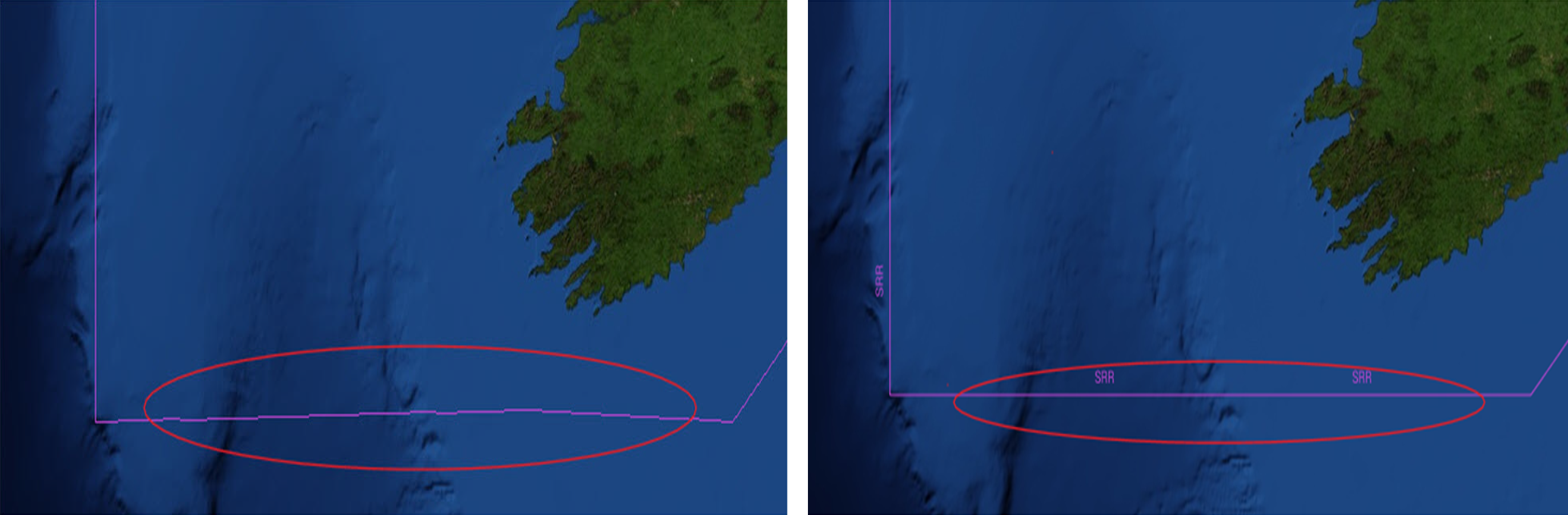
They showed us the above images which were the result of two WMS clients visualizing ECDIS data served by the two geospatial servers. We knew immediately that the image on the left had been published by LuciadFusion. The line that is circled in this image is curved because LuciadFusion fully supports geodesic line drawing, meaning that linear features are calculated correctly by taking the curvature of the Earth into account.
The image on the right, on the other hand, was published by the open-source server solution. This solution does not support geodesic line drawing by default; it just renders straight lines. Not only is this incorrect geographically, but it can impact how the feature data is subsequently measured and used.
In the maritime or aviation industries, this could impact a planned travel route. For example, in the case of our friends at the European company building a Maritime Surveillance system – which was supposed to implement a SAR (Search and Rescue) module – they simply couldn´t rely on a solution that doesn´t accurately locate the position of, for instance, the survivors of a downed aircraft.
Or consider a pilot preparing to make a transatlantic flight, whose airline employs a geospatial server solution to publish real-time maps quickly to multiple users simultaneously.
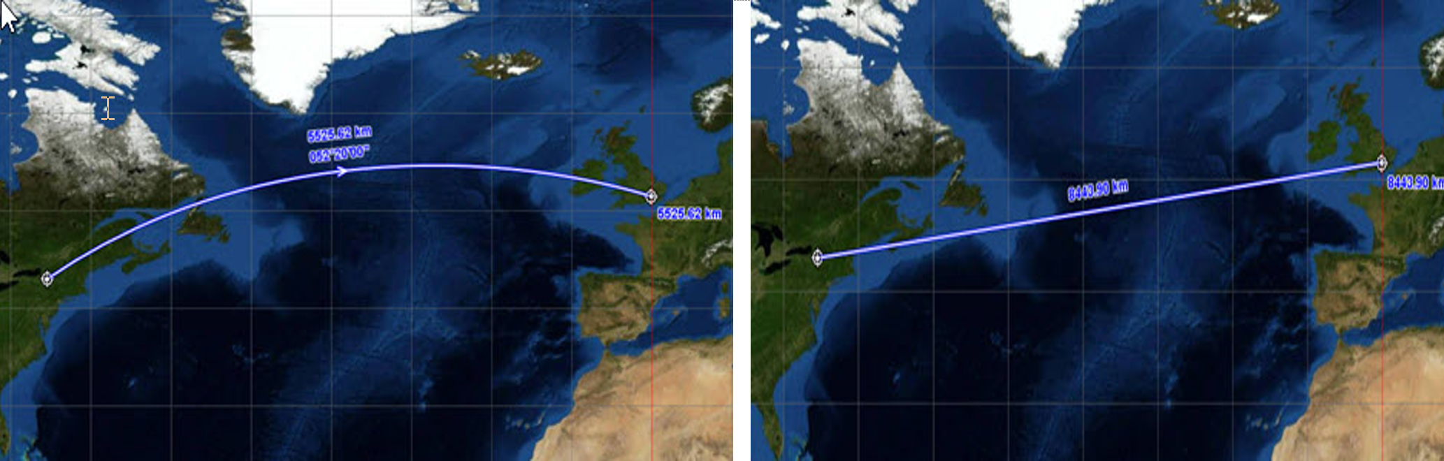
For a flight between New York and London, the geodesic (curved) flight path has a distance of 5525.62 km, and the cartesian (straight) flight path has a distance of 8443.90 km. So if the pilot had to follow the flight plan along the straight line, they would have to fly almost 3000 km farther!
Not only does LuciadFusion support geodesic lines, but it also has a myriad of features that trump those of the open-source solution. For starters, LuciadFusion can connect to hundreds of data sources in their native formats. Data such as flight routes can be fused with a variety of other data such as weather data and forecasts, maps, aeronautical or maritime updates, fuel consumption data, pollution measurements, and real-time sensor information such as radar.
Other LuciadFusion features that stand out when compared to the other solution are:
1. Accurately Displayed Data in Any Coordinate System
With LuciadFusion, users can access and represent data in any coordinate reference system (geodetic, geocentric, topocentric, grid) and in any projection. They can also perform advanced geodetic calculations, transformations, and orthorectification. Regardless of the coordinate reference system of the data, it can be served, fused, and rendered on the fly. Both vector and raster data are accurately and correctly warped.
2. Graph and Routing Engine for Route Calculations
Users can exploit the network structure of their geospatial data and make use of algorithms to construct graphs and solve routing challenges. The graph engine offers support for all kinds of network-related processing, such as shortest path or cross-country movement calculation. It also lets users create flexible cost functions.
3. Aviation and Maritime Standards
For aviation, LuciadFusion lets users model, visualize, and serve aeronautical data such as airspaces, navaids, procedures, and grid MORAs (minimum off-route altitude). This includes options for custom styling. Maritime industry users of the software can rapidly visualize electronic navigational charts in 2D and 3D. LuciadFusion complies with standards defined by the International Maritime Organization (IMO) and the International Hydrographic Organization (IHO). It also decodes data in the IHO S-57 and S-63 (the encrypted version of S-57) formats and visualizes the charts in compliance with the IHO S-52 visualization standard.
4. Optimized Performance, Visualization, and Analysis in Real Time
LuciadFusion is optimized to handle real-time data with GPU-acceleration so that the data can be rendered, visualized, and analyzed in real time, while the data is still relevant. Visualization capabilities can switch between 2D and 3D, and users can perform analytics on real-time data with styling, heat maps, or geospatial or other filtering.
Lessons Learned
For the best results (and maps), choose your map server solution carefully. Server solutions from Hexagon such as LuciadFusion can always be trusted to use the appropriate calculations that are required to publish the map features correctly so that they can be fused with other data sources and visualized and analyzed in real time. Our customers and partners have depended upon Luciad Portfolio technology for decades for real-time situational awareness across their entire organizations.
Learn more about getting started with LuciadFusion on our website.
