


By providing advanced spatial modeling and analysis tools, Hexagon’s Spatial Modeler offers streamlined, repeatable data workflows, reducing the need for user interaction (e.g., mouse clicks). It helps with modeling terrains, finding suitable locations and routes, discovering spatial patterns, and performing hydrologic and statistical analysis, to mention but a few use cases. With asynchronous processing of models, users can start a model and carry on with other tasks, even in a desktop environment. The no-code graphical authoring interface enables users to preview results midway, altering parameters for real-time updates before processing a multitude of data.
As discussed in a previous blog, utilising spatial models for cartographic production stages such as generalisation can help defence and civilian organisations. The same is true for stages where new source data is orientated and vector data is extracted from a new source. In this blog post, we’ll focus on the photogrammetric and point cloud operators in Spatial Modeler.
Capturing photogrammetric workflows
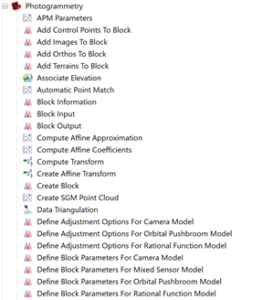
Photogrammetry is well known and regularly used with images from satellite and aerial systems. The mathematics and processes are familiar, having been formalised over 150 years ago. However, the workflow is often a click-heavy process, requiring identification of common points between images and then of elevation points. Whilst the automation of individual stages of the photogrammetric workflow is commonplace with tools like ERDAS IMAGINE, creating an end-to-end photogrammetric workflow without resorting to coding has been difficult. With the addition of photogrammetric operations to the Spatial Modeler, these workflows can now be created in a no-code interface. Where data workflows may have many steps that traditionally a user would read the workflow guide for, these can now be captured in a spatial model and repeatedly used by novice and experienced colleagues alike.
The adoption of point cloud data as an originating source of data for workflows such as vector mapping, change detection, and feature classification has increased with the emergence of smaller format LiDAR sensors, such as the Leica BLK2FLY. The use and visualisation of point clouds can be challenging, due to data volumes and the differing perspective compared to more traditional earth observation data sources. With tools to classify, optimise, and use point clouds, Hexagon offers a platform to exploit this data source, whether captured via photogrammetry or directly by a sensor platform.
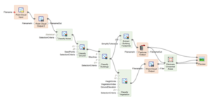
Point clouds can be classified to the ASPRS LAS standard via edge processing within the sensor platform. Alternatively, a Spatial Modeler operator such as Classify Buildings or Classify Vegetation can be used to carry out this step. Extracting building footprints from the classified point cloud is then possible. With the Spatial Modeler, these steps can be run in one model, giving the user an easy way to preview results whilst setting up the model and adjusting parameters. Once finalised, the spatial model can then be used repeatedly on different point cloud datasets.
A spatial model is a collection of operators and is presented as a page containing a set of interconnected operators. Models allows users to create a self-contained functional piece that can be re-used in other solutions. As an important component of Hexagon’s geospatial data authoring system, Spatial Modeler supplies tools for all remote sensing, photogrammetry, and geospatial analysis needs. Learn more about ERDAS IMAGINE to see what it can do for you.
