 About the Author: Alberto González-Díez About the Author: Alberto González-Díez
Alberto González-Díez has been a professor at the University of Cantabria since 2000. He specializes in external geodynamics in the department of earth sciences and condensed matter physics. González-Díez has produced more than 115 scientific writings, most of them published in international journals and volumes, on research topics including the use of mapping, photogrammetry, remote sensing, and GIS for environmental emergency management. |
Hexagon is committed to sustainable development, including protecting land from natural disasters, and has collaborated with its partners at the University of Cantabria in Spain on mathematical research using the tools from the Hexagon Geospatial portfolio to facilitate the fulfilment of United Nations objectives. Among them are the prevention, prediction and mitigation of natural disasters and measuring the level of land degradation and the depletion of soil nutrients when incidents do occur.
At the University of Cantabria, new methodological approaches have been developed to objectively characterize and accurately measure geodiversity features. The latest approach, which uses a variety of remote sensing and photogrammetrical techniques, was tested in small areas with known geological conditions to validate its accuracy.
Photogrammetric techniques
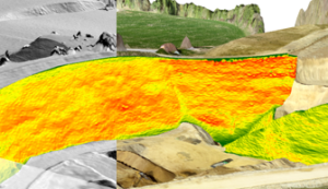
To analyze landscape evolution and measure geomorphic changes caused by mass movements, scientists selected a 7km2 area in a tributary of the Pas River in Spain’s Cantabrian Range. The area features many landslide deposits and markers of mass movement, some dating back 120,000 years, that could be seen in imagery taken during ad hoc and historical flights.
Aerial and terrestrial digital photogrammetric techniques, combined with GPS measurements, enabled scientists to analyze the geomorphic features. They obtained precise landform activity measurements and later compared them with the established mass movement rates. This allowed them to establish the relevance of landslides to geomorphic change.
Remote sensing approach
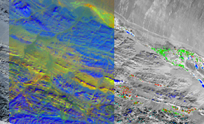
Remote sensing tools offer new ways to perform objective geomorphic mapping, as well. In the Miera River, also in the Cantabrian Mountains, scientists analyzed the suitability of Fast Fourier Transform (FFT) filters to delimit the objective location of geomorphic references belonging to karstic landscapes.
These features were well depicted in the digital elevation models created with LiDAR, and combining that imagery with aerial photos derived a high-resolution digital elevation model (DEM), A digital database was then created, segregating two geomorphic domains according to scale: domain A (macroforms) and domain B (mesoforms), both subdivided into zones of positive and negative relief polarity.
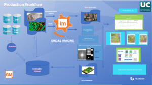
With the help of ERDAS IMAGINE and all the remote sensing tools included therein, professionals can perform these and other transformations during their studies. The common workflow used in both the remote sensing and photogrammetrical approaches can be seen below:
Read the University of Cantabria’s entire study for more information.
What can ERDAS IMAGINE do for you?
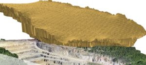
With ERDAS IMAGINE you can create geological cartography by combining DEMs and a variety of other spectral information coming from different images. In addition, drone sensors can support the study of thermal anomalies and hydrothermal alterations and provide 3D realistic representations with the added value of volumetric calculations.
The radar tools included in ERDAS IMAGINE allow for the study of how low frequency radar waves penetrate into non-conductive medium (usually subsoil but also walls, bridges, etc.). Ground-penetrating radar applications are used in the study of coastal sand environments, where it is possible to recognize the stratigraphic sequence developed, mainly constituted by horizontal layers, progradation sequences, the water table and bedrock depth.
Detecting contamination levels in the sand of beaches after fuel-oil spill is another potential use case. The bottom line is that no matter your remote sensing, photogrammetry and GIS needs, ERDAS IMAGINE supplies tools for it all.